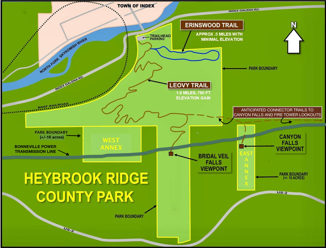
Learn About Heybrook
Heybrook Ridge is located just upstream of the confluence of the North and South Forks of the Skykomish River and just southeast of the Town of Index. The Leovy Trail is a popular ~3 mile roundtrip hike offering fantastic vistas, and the Erinswood Trail is a nearly flat ~3/4 mile loop on its way to becoming fully ADA-compliant. Other hikes are in the plans too. Please see the articles below for more information, and our Newsworthy and Events pages for updates.
For those interested in birds, bees and trees on Heybrook Ridge follow this link Inventory Plants and Animals for a list of plants (164 species) and animals (113 species including insects) found on the Heybrook Ridge parcel, surveyed by our multi-talented board members Bob Hubbard and Cate Burnett.
History of Heybrook Ridge
The Heybrook Story Over Time
In her article “A History of Heybrook Ridge,” historian Louise Lindgren provided a short history of the Ridge, starting with the native Skykomish People, through the early 1920's when the booming timber industry peaked, to the year 2007 when citizens organized to prevent a clearcut and preserve a forest.
In her article “A Story of Cooperation” Lindgren summarized the urgency felt to save the Ridge's trees from clear cutting, the formation of the Friends of Heybrook Ridge, and the cooperative successes that followed.
In her article “The Patron Saint of Heybrook Ridge,” Ann Darlington penned the story of the anonymous donor whose gift kick-started the purchase of land that became Heybrook Ridge County Park.
In “A History of Local Stewardship,” Ann continued Louise's account, covering the support, caretaking and growth of both the Friends of Heybrook Ridge and Heybrook Ridge County Park, from 2008 to the present.
In his article “A Brief History of Index, WA,” historian David Cameron gave us the basic history of the Town of Index, from the 1893 platting of a townsite on a mining claim to its evolution to a recreation-dominated economy.
In his “Vole Angst Sign” anecdote, Bob Hubbard wrote of his 2012 wanderings along the then-undeveloped north base of Heybrook Ridge, and his discovery of a water-running rodent.
From Indigenous Hunters, European Loggers and Lumber Mills to a County Park. By Louise Lindgren, July 19, 2013
Heybrook Ridge has seen the footprints of humans for thousands of years, first from the hunters among the Skykomish People who would have followed their prey deep into the woods and from the women of that tribe, picking plants and berries in the clearings. They could not have imagined that their forest would ever be felled, but the next humans who made their mark on the land did just that.
In 1903 heavy boots of loggers sank deep into the duff as the men of Sylvester Smith's logging teams began felling trees so huge that often one log alone would fill an entire railroad car. Smith began a lumber mill at the base of the north side of the ridge in that year, directly across the Skykomish River from the ten year old town of Index.
By 1908 Smith had sold out to a partnership which expanded his operation, becoming the Index-Galena Lumber Co. In 1911 the mill was producing about 60,000 board feet of lumber per day, and a shingle mill was added in 1912. A Climax geared locomotive chugged ever deeper into virgin forest, heading east for miles along the river to bring out logs that were skidded down steep slopes to rail cars which took them to the mills. Lumber and shingles were then loaded onto cars of the transcontinental Great Northern Railway to be distributed throughout the country and by sailing ships to foreign ports.
On the south side of the ridge in 1910 Louis C. Heybrook and his wife had their smaller Heybrook Lumber Co., which also fed its products to Great Northern rail cars that passed directly by the mill on their way west to Everett and Seattle and east to Chicago. By 1916 Heybrook was listed in R. L. Polk's Everett and Snohomish County Directory as a village of 250 people (compared to Index at 600 pop.), but with only Mrs. L. C. Heybrook listed as owner of the mill.
A prominent Swedish businessman, John Soderberg, who was responsible for the first waterworks for the town of Index as well as its granite quarry to the west, also owned a large share of Heybrook Ridge (32 acres) on its northwestern flank, abutting both Index-Galena ownership on the north and Heybrook's on the south. An oddly shaped five acre piece was cut from his westernmost section and listed on a 1910 map as Ellis Granite. Archaeological exploration in this area may reveal whether any stone was quarried at this place.
World War I increased the market for lumber products, and the Index-Galena mill prospered, producing at its peak in the early 1920s a hundred thousand board feet of lumber per day. Two company logging trains traveled 16 miles up-river to transport logs to the mills. However, by the end of that decade the decline in business had begun.
By 1927 George Bingham had purchased Mrs. Heybrook's property. Unfortunately no records have been found so far detailing the demise of that mill. The Index-Galena Co. land was under trusteeship and headed for several more years of ownership changes. The logged off Soderberg property was transferred to his Western Granite Co. except for the odd “granite quarry” piece that had changed to a new owner, A. E. Crawford.
A map of 1934 shows Snohomish County as owner of most of the former Index-Galena land, and by 1940 that had been transferred to the State Forest Board. The Great Depression had taken its toll. The mills were closed, but a young mixed-species forest had begun to replace the stumps left from those early years of clear-cutting.
The 1975 map shows that much of the northwest side of the ridge was owned by Buse Timber, and that family-owned company waited for many years for its trees to grow to harvestable maturity. Once that growth was achieved in 2007 the story of the citizen effort to save the land from harvest began. The First People of the area, the Skykomish tribe, might well have helped in that effort had they survived as a viable and distinct cultural group. Those who make this century's footprints on the trails of Heybrook Ridge Park may well honor the memory of those who were stewards of the land for millennia.
The Friends of Heybrook Ridge: Our Story of Cooperation by Louise Lindgren
Notice of Logging Causes Alarm
In the fall of 2006 a notice appeared on the general store bulletin board stating that clear-cut logging was proposed for 95 forested acres of Heybrook Ridge across from the small town of Index. A few citizens reacted quickly with a kitchen table confab to plan opposition to the action. Fortunately, one participant had a long-term friendship with a member of the logging company's family, and through that relationship, dialog was begun and continued through the winter. Due to Index's history of logging, the owners of the company (W.B. Foresters) were surprised by the opposition to their plans. They had waited 30 years for the trees to be ready for harvest and expected their land investment to pay off, with a short-term benefit of jobs for townspeople that would be welcomed.
Dialog Avoids Confrontation
Once the timber company owners understood that Index was no longer a logging town, but was instead primarily supported by recreational visitors attracted to the area's scenic values, they agreed to work with the community to seek resolution. In February 2007, Friends of Heybrook Ridge was formed as a non-profit 501c3 organization. From the beginning, the group agreed to avoid taking a confrontational stand, believing that the timber company had a right to profit from its investment. That attitude convinced the company to delay logging for a year so the group could raise $1.3 million to buy the land and preserve it for a park.
Expanding Support for the Friends
With a town population of only about 160, it was clear the Friends needed involvement from supporters throughout the region. The board and other volunteers began fundraising events and outreach to potential supporters in environmental and recreational groups, cultural resource organizations, tourism related businesses, and media of all forms. Support was raised from the Pacific NW and across the nation. A national group of professional book indexers joined the effort simply because the town was named Index. Guidance was offered by the Cascade Land Conservancy (CLC, now named “Forterra”) and the Nature Conservancy.
Small Successes Lead to Large Donations
Most donations were modest, but with over 200 supporters and a few $10,000 donors, by 2008 over $100,000 had been raised. That spring, as the deadline approached with funds still far from goal, an anonymous donor came forth with $500,000. That large donation was enough to create matching funds needed for an application to the Snohomish County Conservation Futures Fund. W.B. Foresters generously agreed to shift the deadline forward by several months and to lower the price to $1.2 million. We were granted $640,000 in conservation futures money and shortly thereafter, negotiations to purchase the property as a gift to Snohomish County Parks were guided by CLC staff and a pro-bono lawyer for Friends. The Buse family's timber company sealed the deal in July 2008, with all partners in the effort satisfied that, indeed, the Friends' vision of Heybrook forest's preservation for passive park use with natural and cultural resources interpretation was the best possible outcome for all, forever.
By Ann Darlington, March 2025
In her piece “A Story of Cooperation,” Louise Lindgren wrote of the $500K anonymous donation making possible the land purchase that became Heybrook Ridge County Park. In 2018, the donor's family gave us permission to end his anonymity and sing his praises.
Conway Barbour Leovy, PhD., knew that his days were numbered by the cancer that finally caught up with him in 2011. When he made his game-changing donation to FOHR, he asked that, at least for a time, his illness and donation remain unidentified. He thought of his gift as his personal legacy, but he did not want to be public about it during his lifetime.
A true Renaissance man with boundless energy and a passion for new ideas, Conway began his career as a weather forecaster for the Air Force in the 1950s. Over the next 40+ years he earned degrees in physics, mathematics, and meteorology and was a researcher for NASA's missions to Mars. Winner of multiple awards for research in planetary atmospheres, Dr. Leovy co-created the first-ever computer model of Mars's global atmosphere. As early as the mid-70's, he did key research alerting the world to the enlarging ozone layer over the Antarctic and linked it to manmade pollutants. He taught atmospheric sciences at the University of Washington for over 30 years.
Conway was also a down-to-earth outdoorsy fellow and ardent hiker, whose many adventures often started from his cabin in Index. As John Edwards wrote in the Wild Cascades journal, “Early plans for the proposed borders of the Wild Sky Wilderness were hatched in his chalet in Index, where he had an intimate knowledge of the lay of the land.”
And Conway was a poet. In his poem “Gathering” he wrote,
Moonlight sifts through thin cloud layers,
On a clearing deep in the woods,
And on a home that's made for one.
A group of neighbors gathers there
To save some land nearby our town.
Good yeast is rising all around.
The Leovy Trail to the top of Heybrook Ridge honors his generosity, vision and yes, his legacy.
Photo taken in July, 2008 by Ann Darlington, who had no idea she was hanging out with the Patron Saint of Heybrook Ridge. Shot from the top of the Lake Serene Trail, showing the south side of the Ridge in the background
By Ann Darlington, March 2025
18 Years as Community Stewards of Heybrook Ridge County Park
In 2007, our $550,000 “matching funds” donation to Snohomish County Parks and Recreation (“SnoCo Parks”) enabled their successful bid for a $700,000 Conservation Futures grant from the Snohomish County Council. Our combined funds led to the 2008 acquisition of ~95 acres on the north (town side) of Heybrook Ridge and another ~35 on the south (Highway 2) side. Covenants attached to our donation meant that “in perpetuity” the non-profit Friends of Heybrook Ridge (FOHR) would participate in all aspects of the development of Heybrook Ridge County Park, and the land would always belong to the public as a Snohomish County Park.
All good, except that the property was essentially land-locked, with virtually no access from either side of Heybrook Ridge. So for the next several years, we strove to raise funds independently and in concert with SnoCo Parks. The slow, steady hunt was on to find willing sellers of land for a parking lot and trailhead with public access from the Index-Galena Road, which lies along the north side of the Ridge. It wasn't enough to save the trees; it was time to gain access and build a trail to the summit, with its awesome panoramic views including Mt. Index, Bridal Veil Falls, and the Skykomish Valley, from Mt. Persis to Baring Mountain.
It Takes Money
2008 marked the first year of FOHR's “Heybrook Hoedown” fundraiser, held annually through 2020 until Covid risks made it unsafe. Every year, supporters danced to music by Spare Rib's bands, enjoyed food and drink, and generously donated (and purchased) valuable goods and artwork. FOHR volunteers also staffed a booth every year at the outdoor Index Arts Festival, informing folks about the Heybrook Ridge County Park (HRCP), selling swag (like colorful socks and FOHR tees) and soliciting donations. Altogether, these efforts and donations through our website netted thousands of dollars to help finance park land purchases, WTA trail work, critical surveys and more.
In 2013, with our testimonial and grant-writing support, SnoCo Parks was awarded a $299,000 Conservation Futures Grant to fund property purchases for trailhead and parking lot access with an entry off the Index-Galena Road. Meanwhile, Chris Mueller, Senior Park Planner (with a little help from his Friends) scrambled all over the north side of the Ridge, aligned a trail to the summit, and initiated its construction. The results of his skill and commitment would ultimately become the Leovy Trail.
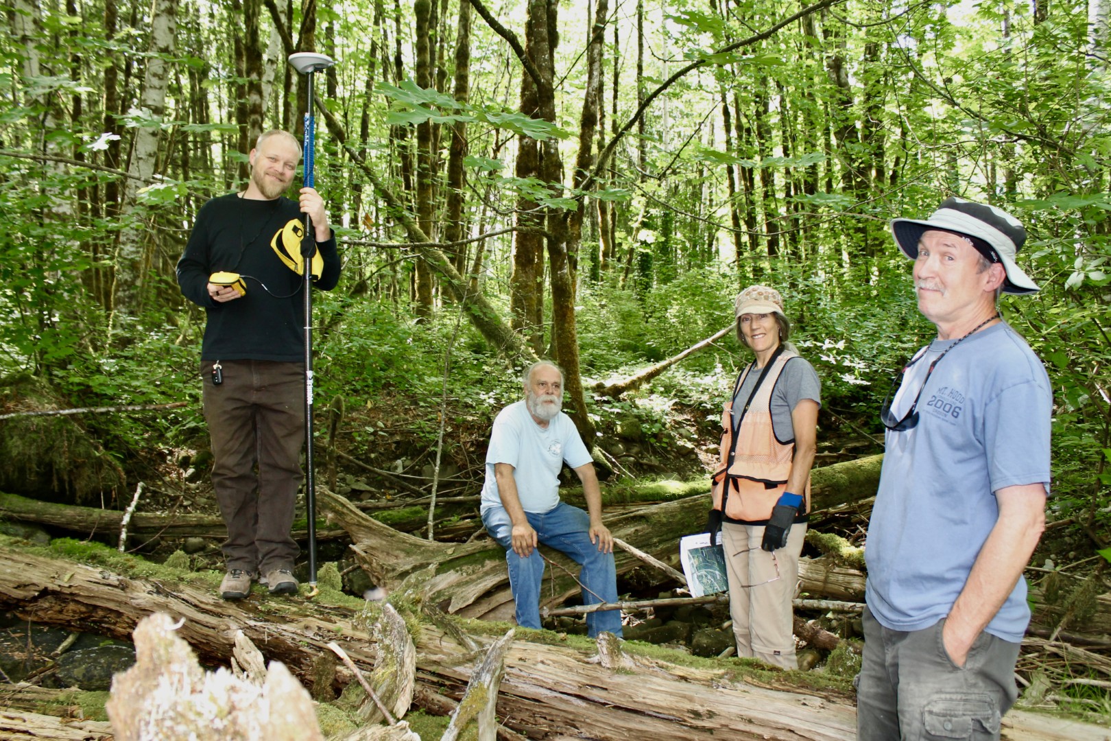
Chris Mueller w/FOHR BOD members Bob Hubbard, Cate Burnett & David Meier begin trail alignment for HRCP's 1st trail. June, 2013 photo by Ann Darlington
Park Expansion and Trail Development
Willing sellers were found, vetted, and three properties adjacent to park boundaries were purchased by Snohomish County in 2013-2014. The properties were later developed into a grass parking lot and a roughed-in lowland ADA trail.
FOHR board member Bub Hubbard showed impressive foresight in his quest to add another 10 acres on the south (Highway 2) side of Heybrook Ridge. His rambling hikes brought him a short distance east of the Park's boundary to a stone outcropping that boasted an astonishing view of Canyon Falls. We bought the 10-acre section that included that viewpoint in 2014 for $25K and donated it to SnoCo Parks, knowing it would be years before we could develop it. Find it on the map, newly labeled “East Annex,” and enjoy the view here:
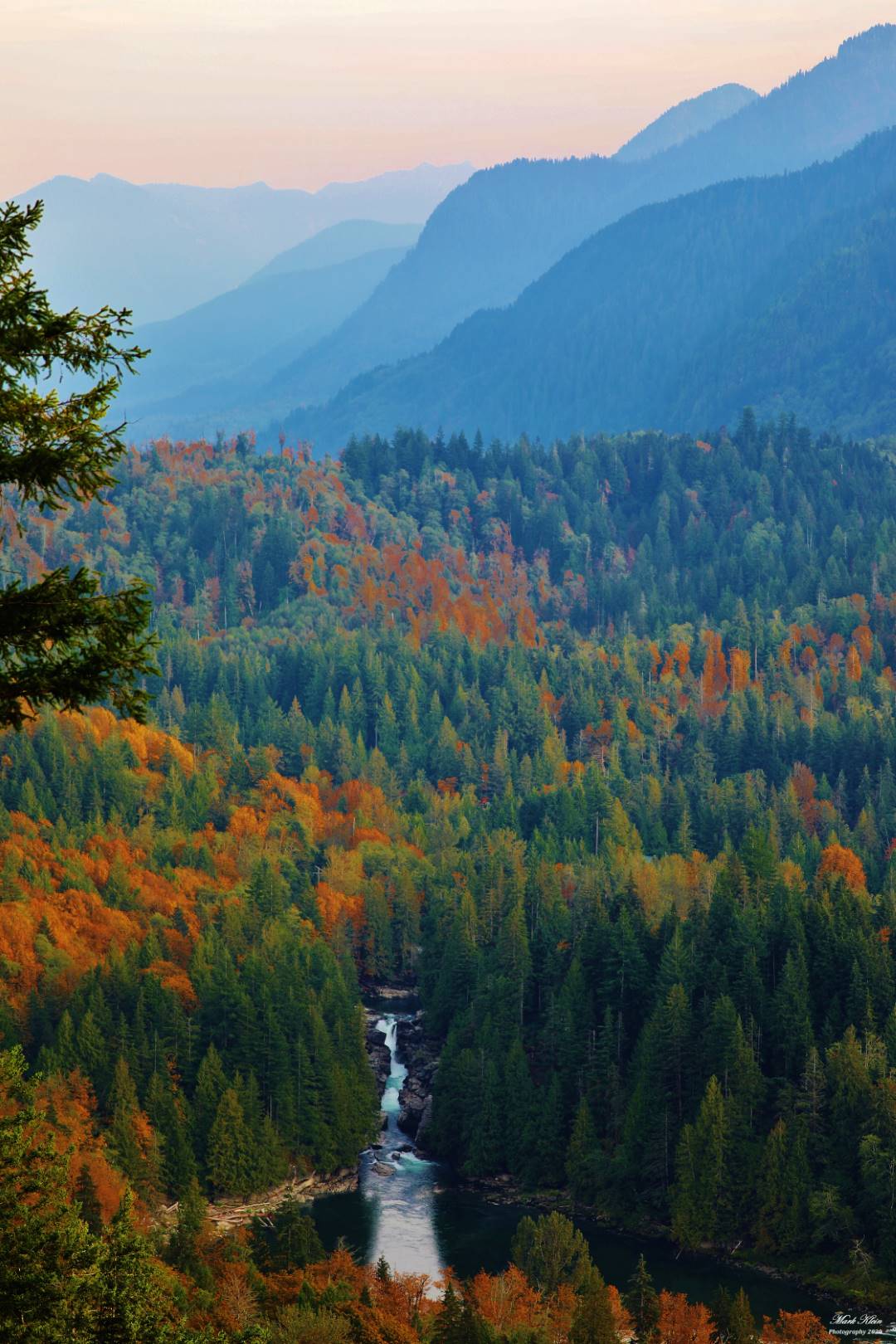
Canyon Falls from HRCP, photo by Mark Klein.
With shared financing from SnoCo Parks and FOHR, in 2016 and 2017 multiple WTA work parties refined the roughed-in 1st (now “Leovy”) trail. Check out WTA's 2017 account of it here.
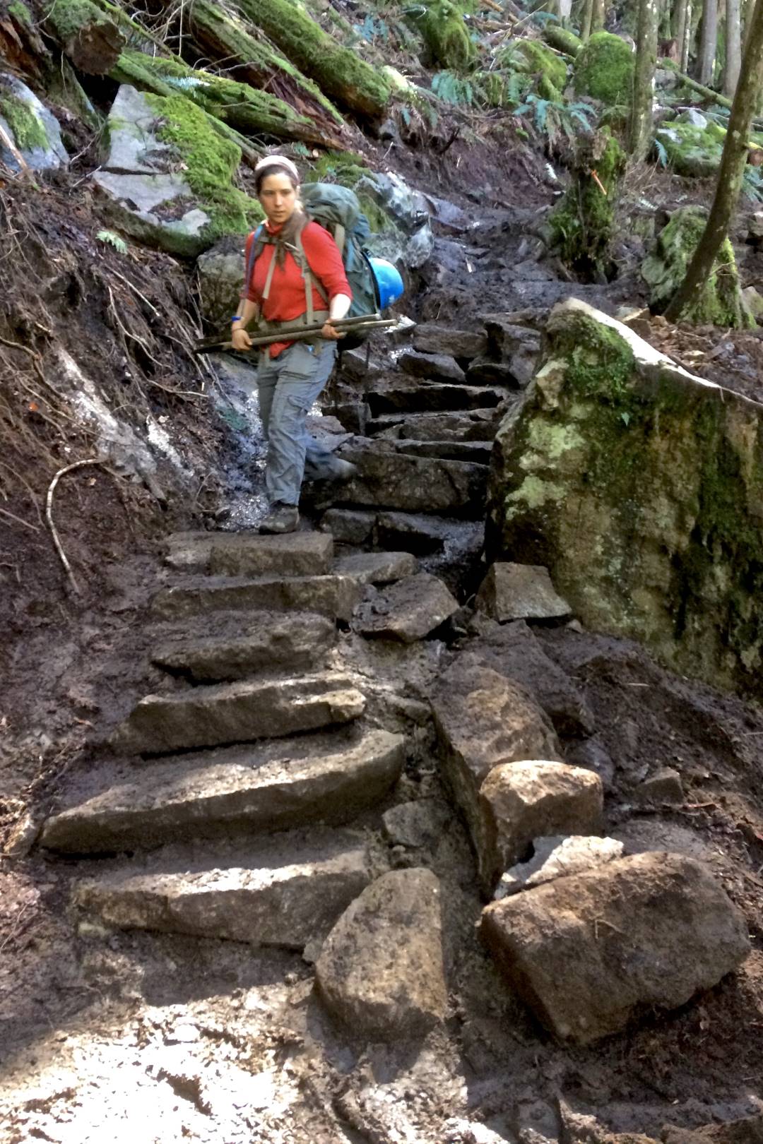
WTA's Marla Martin led the crews who built this rock stairway from nearby materials. Photo by Ann Darlington.
And in 2018, WTA returned to clear a 6/10-mile loop trail at the base of the north side of the Ridge. We wanted to create an ADA-compliant trail that could be enjoyed by folks of all abilities. (“ADA” stands for the American Disabilities Act of 1990, which sets requirements for accessibility, like the trail's surfacing, width and rise.) The trail meanders through a lush canopied forest with an old raised rail line on one side and a seasonal creek on the other. There, one immediately feels immersed in a golden-green wilderness, something rarely experienced from, for example, a wheelchair or a stroller. The work WTA did that year (and again in 2019) on the trail that we now know as “Erinswood” has held up well with frequent use by hikers.
Also in 2018, Kevin Teague (then the SnoCo's Senior Parks Planner) and I applied for grants to fully develop the trail, an accessible parking lot, and an enclosed portapotty (no vault toilet allowed due to watershed protection regs); to commission multiple surveys (like critical area and cultural resource studies), and to create interpretive trail signage explaining the local history, flora and fauna. FOHR donated $10,000 as a show of local stewardship and sincere community interest. The grant process was complicated, convoluted and lengthy, involving County, State (RCO), and Federal (National Park Service) government branches, but in the end, we finally won a federal Land and Water Conservation Fund grant of $432,000 in 2021.
Back to that view of Canyon Falls. In 2019, with oversight from SnoCo Parks and FOHR, volunteer Neil McWee felled selected trees to provide a fantastic sightline corridor of Canyon Falls and a 180-degree view of the Skykomish Valley. Local contractor Eric Malm used nearby granite to enhance an existing rock outcropping for an elevated rest spot at the top of the viewpoint. Earlier ideas to create both a shelter and a connector trail through the forest below the Bonneville Transmission tower line proved too difficult and costly, and no further construction is planned for this site. Instead, we will provide a bench for the rest spot, and seek easements from landowners along and nearby the tower line for an official (and far less pricey) trail to the Canyon Falls viewpoint.
We try to keep a watch out for available land to enlarge and enhance the Park, and to protect Heybrook Ridge from commercial development, like logging, private estates or condos. So when in June 2020 three lots became available on the upper north side of Heybrook Ridge (that were facing and visible from Index Town), we joined SnoCo Parks in an application for another Conservation Futures grant. It took a couple of years, but in early 2021 SnoCo Parks was awarded a ~$210,000 grant, and ~15 acres were then added to the Park (shown on the map as the “West Annex”). The Leovy trail abuts the property near the small waterfall at the rest point located at about ¾ of a mile up the trail. One day the Park will have a loop trail to the West Annex, a good way to take some of the heavy use pressure off Leovy as well as preserve the forested view of Heybrook Ridge from the North Fork valley.
Starting with the original 130-acre purchase in 2008 and including each smaller parcel added thereafter, Heybrook Ridge County Park now contains ~166 acres of public land.
Pandemic Pause and a Re-energized Present
As in so many ways worldwide, the pandemic slowed everything down in the early 2020s. SnoCo Parks plugged away at finalizing permits for Erinswood development, and received grant extensions through the summer of 2025 from the Feds and the State to complete the trail. They are now kicking the project into full gear with boots (and machinery) on the ground by June, 2025.
Under Sue Cross's leadership, FOHR has likewise sped up its work on nine interpretive signs for Erinswood Trail, covering topics from the area's history of native Americans to the Index Galena Lumber Company and its mill town, the clearcutting of Heybrook Ridge to its natural regrowth, and today's vibrant flora and fauna. FOHR will finance eight ADA-compliant benches to be placed along the Erinswood Trail as well as two sturdy regular benches for the Leovy Trail (one at the waterfall and another at the summit's Bridal Veil Falls Viewpoint) and a 3rd bench for the Canyon Falls Viewpoint.
Keep an eye out for updates on this website's “News Worthy” and “Events” pages. Come enjoy the trails, join in on the monthly Nature Walks, attend our meetings. Together we will participate in the living history of Heybrook Ridge and the Skykomish Valley.
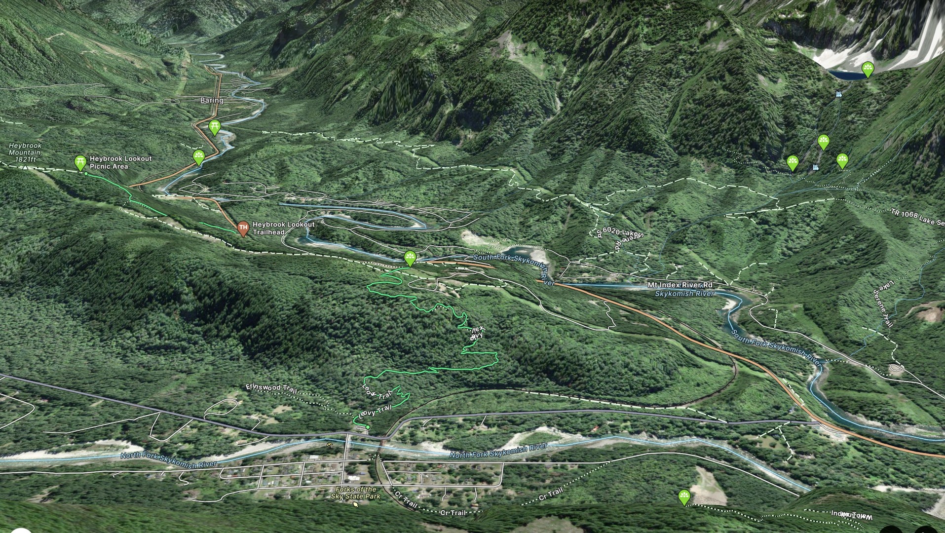
Fatmap.com photo showing Heybrook Ridge and the massive beauty of the Skykomish Valley.
Amos and Persis Gunn platted the townsite of Index on their mining claim in 1893. The Gunns realized the potential for growth because of the recently completed Great Northern Railway which bisected the town and would facilitate the movement of goods and people from Puget Sound across the country to St. Paul, Minnesota. With the town bordering the North Fork Skykomish River, surrounded by scenic peaks of the Cascade Mountains, and along the original trail to the gold and silver mines of nearby Monte Cristo, the Gunns had visions of establishing a community based on mining, logging, and recreation.
John Soderberg added granite quarrying to the industrial base and by World War I, that and the Index-Galena saw/shingle mill, as well as copper from the Sunset mine created huge economic opportunities. A population of some 600 lived in homes, five hotels, and nearby lumber camps.
The 1930s Depression closed most natural resource-based manufacturing, causing the population to drop sharply. In 1942 the small high school graduated its last class. Many early wooden framed commercial buildings also burned or were removed from the riverbanks because of flooding, leaving only a few still standing as reminders of the early years. Among these are the Bush House Inn (on the Washington and National Heritage Registers) and the former Index Tavern, now the River House. Most original homes remain, some moved due to river flooding and erosion. The Gunn house still stands in its original location along the river at 7th and Ave. A. The Index-Pickett Museum was moved from the riverbank at 9th and Ave. A to the lot across from the store that originally held a fine, two-story hotel.
The town was finally incorporated in 1907 and the 1910 census count was 192 residents. The 2020 census now lists 155, making it the smallest in western Washington. It is home for the grade K-7 Index School District #63 and FPD 26 as Sky Valley Fire, which also serves nearby residents. With its spectacular river and mountain setting, recreation now dominates the local economy.
David A. Cameron, Ph.D.
Read more about the town of Index at the website of the Index Historical Society as well as an in-depth article at https://www.historylink.org/File/20911.
A couple years back, when the Index-based nonprofit organization Friends of Heybrook Ridge was involved with fundraising activities aimed at purchasing a 130-acre parcel of land directly across the river from Index, so the forest there could be preserved, I was out hiking on the park quite a bit, looking at different ways of getting from the bottom to the top, so when we got the parcel we could eventually pick one of these routes—the best—to put a trail on. I thought it would be a good idea to keep track of all the plant species I came across and pretty soon I had a fair sized list, a plant inventory. The list soon grew to the point where I hardly ever found a new species, so I started adding animal species to the list, as well as any insects I could recognize. Cate Burnett, another member of Friends of Heybrook Ridge, also got into hiking on the ridge and plumping up the list.
I was out on a hike on the property one day, down at the base of the north side, approaching a small pond with wide flat beaches of damp silt and clay, when a small mouse-like critter jumped out of the leaf litter in front of me and ran down on the beach. There are so many small critters like that that I doubted I'd ever know what this one was. I regretted not memorizing the pictures in a field guide to mammals that was rotting away on a shelf at home. Too bad.
I thought he would have gone down the beach a ways and back into the woods but instead he ran down to the water and shot straight out across the surface of the pond. He didn't sink in the water, or even slow down. Like a windup toy with limbs whirling too fast to see, he kicked up ruckus of spray, and made the Roadrunner look like a geriatric mollusk. In a few seconds, he was diving into the leaf litter beyond the pond, and there was nothing but ripples in the water to say anything ever happened.
I was nonplussed. But I knew I had him now. His behavior gave him away; when I checked the book later I found he was an aquatic vole, also called a water vole. But a name is only part of his identity; I wanted something to describe his distinctness, his gestalt, something expressible in haiku.
The ripples told this to me:
Just to make darn sure
I don't feed a predator
I run on water.
Friends of Heybrook Ridge
P.O. Box 265
Index, WA 98256
[email protected]
Friends of Heybrook Ridge is a not-for-profit 501(c)(3) organization. Our Federal ID is 51-0629374.
Contributions are tax-deductible to the full extent allowed by the law.